Digitisation can sound like an administrative exercise but, in exploration, it helps change the quality of the decisions we can make: paper maps, survey results, sample locations and reports that once sat in separate files can be placed in the same digital framework, turning scattered historical clues into clearer questions about where field teams should work first and what they need to check.
It does not create new geological evidence. It shows us more clearly where the old evidence agrees, where it conflicts and where important gaps remain.
Putting separate records on one map
Practara brought together regional geological mapping, historical exploration reports, airborne geophysical surveys, radiometric data and historical geochemical records. It is also reprocessing historical magnetic and electromagnetic survey data in the areas where coverage exists.
A basic but important step is georeferencing, which is basically tying an old map to a known Earth coordinate system so every point has a location that can be compared with other data. As the US Geological Survey explains, this is what allows historical maps to be combined with modern spatial data.
For us, that means a feature shown on an old map can be compared with the current licence boundary, mapped rock units, radiometric readings and sample locations. Each layer of referenced information then helps answer a different question:
geological mapping shows which rocks and structures are exposed at the surface
radiometric data record changes in natural gamma radiation and can help map surface geology and possible uranium-bearing areas
magnetic data can help trace changes in basement rocks and structures beneath surface cover, while electromagnetic data can help outline changes in conductivity, including buried channels
geochemical records show the composition of earlier samples and where they were taken
The value comes from comparison. If interesting features from several independent layers point to the same area, the case for a field check becomes stronger. And — just as importantly — if they do not, the specific area of interest can be revised or set aside.
Three licences, three questions
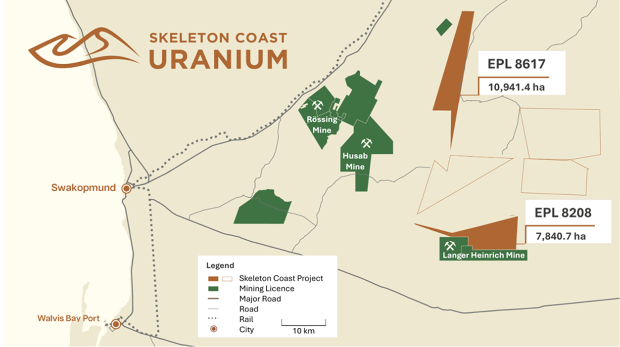
Before looking more closely at each of the three licences, it helps to understand the mines being used as regional reference points: Rössing, Husab and Langer Heinrich, all major, operating open-pit uranium mines in Namibia’s Erongo Region.
Rössing has produced uranium since 1976, while production at Husab began in 2016. In 2024, Husab ranked third and Rössing ninth among the world’s uranium mines by output, together accounting for about 11% of global production. At both mines, uranium is associated with intrusive granitic rocks, including alaskite
Together, the three mines show that both geological settings have supported uranium production at scale in the region, helping to illustrate the different characteristics we are looking for on each of our own licences.
EPL 8617 covers about 10,491.5 hectares, approx 18km east of Rössing and 17 km east of Husab. Historical reports suggest that the intrusive rocks and structures associated with uranium elsewhere in the Valencia–Khan corridor may extend towards the licence, and reported radiometric anomalies provide another indication of potential.
The question is whether the rock type, structure and radiometric readings — which record natural radioactivity — point to the same places on EPL 8617.
EPL 8208 covers about 7,840.7 hectares and adjoins the mining licences that host Langer Heinrich. The digital assessment highlights interpreted tributaries to the ancient drainage system that hosts the mine, together with elevated radiometric readings.
The question here is whether the drainage routes and calcrete-bearing sediments line up with those readings, and whether future fieldwork and surface sampling support the same areas.
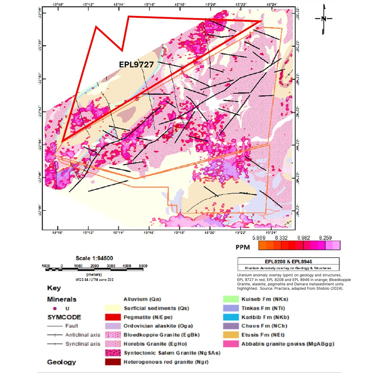
EPL 9727 covers about 12,081 hectares and presents two different geological target concepts. Its north-eastern area is interpreted to contain cover related to ancient drainage, while its south-western area exposes older basement rocks, including the Bloedkoppie Granite and associated pegmatites.
The question is whether fieldwork supports either — or both — ways that uranium can occur in the region.
Radiometrics and Geology of Skeleton Coast Uranium’s EPL 9727
These are not three versions of the same target, so the benefit of one digital framework is that we can apply the same standard of evidence while asking a different geological question on each licence.
What “high priority” means
The areas identified so far are properly described as preliminary, high-priority conceptual exploration targets. Each word matters: we are able to start prioritising areas that need to be explored.
Further integration and analysis are now being used to rank areas for the 2026–2027 exploration programme and determine which, if any, warrant later drill testing. The programme is expected to include:
field mapping to confirm whether the expected rocks, structures and drainage features are actually present
surface sampling to provide laboratory measurements from the rocks and sediments
additional airborne and ground surveys to test whether a response forms part of a coherent target or is only an isolated reading
The aim is to move from an interesting historical observation to a target supported by numerous lines of evidence — only then can we make a disciplined decision about whether further spending — including drilling — is justified.
The value of digitisation is therefore just not the number of files in a database. It is the ability to compare old information on equal terms, reject weak ideas earlier in the exploration process and send field teams to a smaller number of clearly defined areas with specific questions to answer.
For EPLs 8617, 8208 and 9727, that common starting point is now in place. The next test is on the ground.
Share
Leadership Insights
From historical records to 42 ranked uranium targets
October 14, 2026
We have completed the digitisation of the historical exploration data across all five Namibian licences on schedule, bringing approximately 140 historical sheets into one digital mapping system.
Earning the Right to Drill: what our new NI 43-101 reports mean
August 11, 2026
On August 4, we announced the filing of independent NI 43-101 technical reports for EPL 8208, EPL 9727 and EPL 8617, prepared by Christopher J. Male, Senior Geologist at Practara.
A tale of two uranium models: EPL 9727 and EPL 8208
July 2, 2026
Being close to three of the world's major uranium mines matters, but EPLs 9727 and 8208 give us something else as well: they give us two different opportunities to find uranium.