A tale of two uranium models: EPL 9727 and EPL 8208
July 2, 2026
EPL 8617 is one of those licences that jumps out from the map, covering 10,492 hectares and sitting in a proven uranium district.


Nathan Chutas, PhD, CPG
CEO and Director
Skeleton Coast Uranium Corp.
May 25, 2026
Historical targets, modern standards: how we are approaching the data
In uranium exploration, historical data can be useful, but it can also be misused. This is why I think it is worth being very clear about how we look at using it at Skeleton Coast Uranium.
Across our five optioned EPLs in Namibia’s Erongo Region, there is a meaningful body of historical exploration work, including past drilling, airborne radiometric surveys, mapping, sampling and anomalous uranium results.
The history matters because it tells us these licences are not a blank canvas. They have been looked at before, and in some cases they were looked at hard enough to generate targets that are still worth paying attention to today.
But there is a line we are careful not to cross.
Historical data is not the same thing as current data, and historical estimates are not current resources. Past drill results do not become more reliable just because they are quoted often. And anomalies on an old map are not discoveries.
I think this discipline matters.
If an earlier program produced useful information, then we want to know about it. But we still have to test and verify it, not just repeat it because it sounds good in a slide deck. We view the historical work across the portfolio, not as something to lean on blindly, but as a starting point — and starting points matter.
Take EPL 8617 as an example. We have historical percussion drilling adjacent to the EPL that consisted of 127 holes totaling 1391 m. The historical ore resources for this area, using boreholes containing at least one 1 m intersection of 100 g/t U3O8 with a lower cutoff grade of 50 g/t are 35 million tonnes at an average grade of 120 g/t U3O8, equivalent to 9.2 million lbs.
This means there is a real work history we can build on.
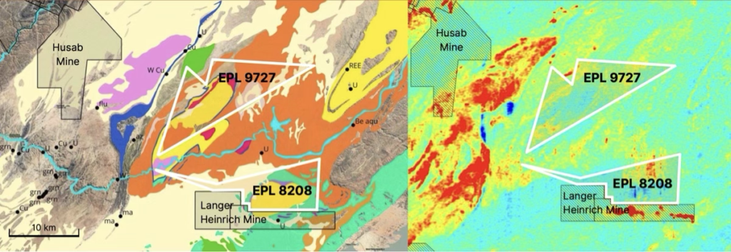
The same goes for EPL 8208 and EPL 9727, where we have radiometric surveys, anomalous zones over river sediments, carnotite in joints, and values up to 260 g/t U3O8 on EPL 8208, while EPL 9727 has both intrusive and surficial uranium potential.
Again, none of this is a shortcut, but it helps frame the questions we are asking on the ground, a framework for exploration.
We are also reviewing all available airborne survey data flown by the Namibian government over the EPLs, along with archived exploration reports and data held by the Ministry of Mines and Energy. From there, the program may include field mapping, outcrop sampling, topographical surveys, locating historical drill collars, geochemical and radon emanometry surveys, hyperspectral remote sensing, high-resolution airborne radiometrics and geophysics on selected targets, and first-pass drilling.
This may all sound technical, but the basic idea is simple: take every piece of historical information we can find, check what still holds up, and use it to narrow down where we should spend time, capital and drilling.
So when we talk about historical data at Skeleton Coast Uranium, we are talking about a body of exploration history that can potentially help us target smarter and move faster.
The historical resource estimates provided here are based on data obtained and prepared by previous operators and have not been verified by either the Company or a qualified person as defined by NI 43-101 and the rules promulgated thereunder regarding the reporting of historical resource estimates. These estimates are considered historical and do not conform to current NI 43-101 standards.
