Then, on October 8, we announced 42 ranked airborne uranium targets across the five licences, including 13 high-priority targets, following a fresh analysis of regional government survey data.
There is plenty still to check, but these two pieces of work give us a much clearer starting point for getting onto the ground.
What the work gives us
Maps, surveys and drilling records previously spread across separate documents can now be examined together. Practara, the South African technical consultancy advising on our exploration programme, has completed that compilation across all five licences.
That allows us to compare an old survey reading with the geology and landscape around it: does it follow a particular rock formation or an ancient river channel? Is there enough information to locate an anomaly reliably? These are practical questions that help us decide where to start and what to check.
Alongside this, ASST Namibia, an independent geophysical contractor, re-examined government airborne surveys flown in 1994 and 1995. Its analysis identified and ranked the 42 targets, which Practara checked against our licence boundaries and earlier geological work.
For me, the value here is to have a clearer vision of target priorities to investigate.
Obviously, these are signals detected from the air, not discoveries or drill targets, so they do not establish uranium grade nor tell us exactly what lies at depth. Our next job is to find out what is causing them.
Why EPL 8617
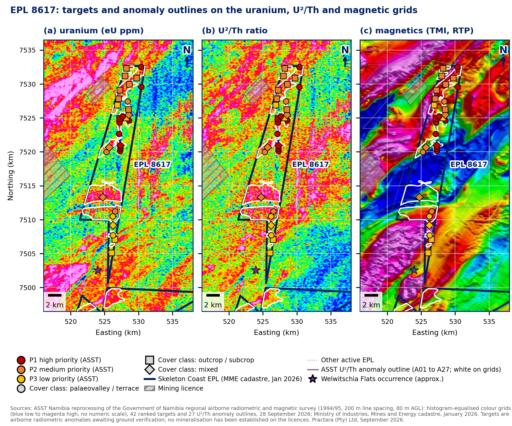
EPL 8617 holds 30 of the 42 targets and ten of the 13 high-priority targets. It was already our first choice for field work, and the new results reinforce that decision.
The highest-priority targets cluster along an ancient valley in the north of the licence. The survey readings are consistent with uranium that may have accumulated in the valley sediments (as we discussed in our previous post on the uranium models). Elsewhere on the licence, the data also give indications of targets associated with granitic rocks. Both concepts need testing, but the northern valley gives us a focused place to begin.
We plan to start field work late in the fourth quarter of 2026.
(The licence covers privately owned farmland, and access agreements are under negotiation, so we need to conclude those before our team can get onto the ground.)
EPL 8617 hosts 30 targets, including ten high-priority targets. The northern palaeovalley is the first focus for ground checks. Source: October 8 release, Figure 3; ASST Namibia, September 2026. All targets await ground verification.
Where the other targets sit
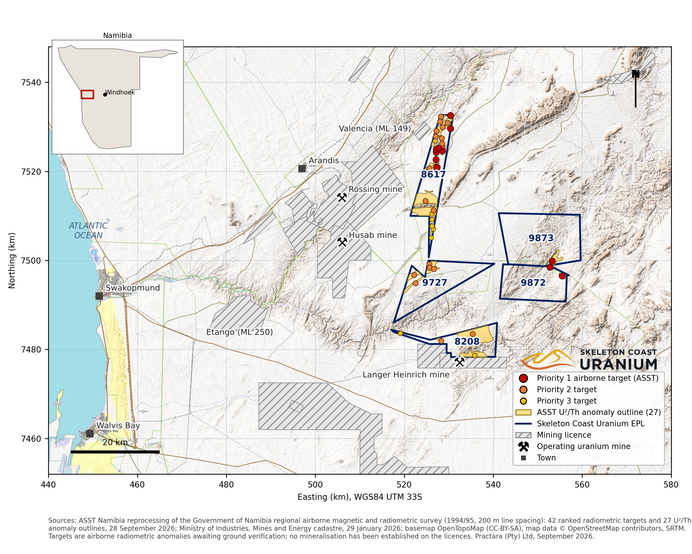
The other three high-priority targets lie along the shared boundary of EPLs 9872 and 9873. These licences had the least historical coverage, so having specific areas to investigate is an encouraging development.
EPL 8208, four targets sit within four anomaly outlines. The largest outline covers the Etusis dome and Salem granite in the east, while a smaller uranium-selective response lies in the covered palaeochannel corridor within one kilometre of the Langer Heinrich mining licence boundary
EPL 9727 hosts five second-priority targets in three anomaly outlines. The largest outline lies on the northern boundary, around four kilometres south of the Welwitschia Flats surficial uranium occurrence.
These targets give us further opportunities to investigate both uranium associated with granitic rocks and uranium that may have collected in ancient river sediments.
The 42 ranked airborne targets across Skeleton Coast’s five licences. All await ground verification. Source: October 8 release, Figure 1; ASST Namibia, September 2026.
What happens on the ground
The next stage is to check whether our interpretations hold up.
Our geologists will map the rocks and use handheld instruments to investigate the radioactive responses, and, where the source is hidden beneath cover, the planned follow-up includes radon surveys to help investigate it. Selected targets supported by that work would then receive more detailed airborne surveys.
Work within the Namib-Naukluft National Park on EPLs 8208 and 9727 will also depend on the necessary park entry permits. The order of work has to reflect both the geological evidence and where we have permission to operate.
As I wrote in “Earning the right to drill”, each stage should give us a stronger foundation for the next decision. As a geologist, I want to see whether the clues hold up in the field. As CEO, I want those results to guide where we spend next.
Now I’m looking forward to getting onto the ground and finding out which targets deserve to go further.
—
The airborne targets remain unverified. No mineralisation or mineral resource has been established on the licences, and nearby deposits do not demonstrate what is present on our ground.
Share
Leadership Insights
From historical records to 42 ranked uranium targets
October 14, 2026
We have completed the digitisation of the historical exploration data across all five Namibian licences on schedule, bringing approximately 140 historical sheets into one digital mapping system.
Earning the Right to Drill: what our new NI 43-101 reports mean
August 11, 2026
On August 4, we announced the filing of independent NI 43-101 technical reports for EPL 8208, EPL 9727 and EPL 8617, prepared by Christopher J. Male, Senior Geologist at Practara.
A tale of two uranium models: EPL 9727 and EPL 8208
July 2, 2026
Being close to three of the world's major uranium mines matters, but EPLs 9727 and 8208 give us something else as well: they give us two different opportunities to find uranium.