A tale of two uranium models: EPL 9727 and EPL 8208
July 2, 2026
EPL 8617 is one of those licences that jumps out from the map, covering 10,492 hectares and sitting in a proven uranium district.



Nathan Chutas, PhD, CPG
CEO and Director
Skeleton Coast Uranium Corp.
July 2, 2026
Being close to three of the world’s major uranium mines matters, but EPLs 9727 and 8208 give us something else as well: they give us two different opportunities to find uranium.
In Namibia’s central Erongo Region, uranium is found in two main geological settings. At Husab and Rössing, it occurs as a primary mineral in granitic rocks known as alaskite. At Langer Heinrich, the uranium mineralization is secondary, as it has been remobilized by meteoric water and deposited in the sediments of ancient river channels.
For those who are not geologists, the distinction changes what we look for and how we look for it.
Two of our licences, EPL 9727 and 8208, give us reason to investigate both of those geological stories. And this matters because it means we are not relying on one exploration concept:
The Each style of uranium mineralization leaves different clues that require a variety of mapping, radiometric surveys, sampling and drilling to explore further. Having different bodies of data allows us to compare targets and focus our time and exploration dollars where the evidence is strongest.
Of course, having two different styles of geological models does not guarantee a discovery. However having different target types give us more than one credible place to start. And, in exploration, that’s a critical advantage.
Let’s start with EPL 9727.
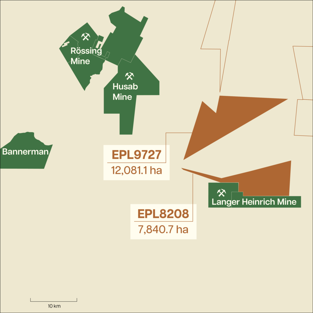
EPL 9727 covers approx 12,081 hectares, about 15 kilometres east of the Husab Mine and 25 kilometres southeast of the Rössing Mine.
Historical work suggests EPL 9727 contains alaskite, the same broad type of granitic rock that hosts uranium at Husab and Rössing (two of the world’s major uranium mines). This is important because it tells us the licence may contain one of the essential geological ingredients needed for this type of uranium deposit.
But alaskite is only a favorable rock-type, not a discovery. Not every piece of alaskite contains uranium, and even uranium-bearing rock may not have enough grade, thickness or continuity to become economically meaningful.
That is why the next stage of our exploration will look closely at the extent and orientation of the alaskite bodies. In this type of deposit, places where the rock thickens, bends, fractures or meets surrounding rocks can be more favourable for uranium to collect. We have not yet established whether those features are present on EPL 9727, but that is what the upcoming mapping, surveys and sampling are designed to test.
EPL 9727 also contains younger desert sediments and calcrete linked to palaeochannels, or ancient river systems. Over long periods of time, weathering chemically mobilizes uranium from rocks in the surrounding landscape. Groundwater can then carry that uranium through old drainage systems, and under the right conditions, the uranium can then precipitate and become concentrated in calcrete, often as carnotite, a uranium-bearing mineral.
So EPL 9727 gives us two geological possibilities to work with: uranium in bedrock (“intrusive”) and uranium deposited in ancient river channels (“secondary mineralisation”).
This means we are not relying on one exploration concept, but two established Erongo-region uranium models to test.
EPL 8208 presents a different kind of question.
EPL 8208 covers roughly 7,841 hectares and shares approximately 15 km of border (N-NW) with Langer Heinrich, a uranium mine built on an ancient drainage system. At Langer Heinrich, carnotite occurs within sediments that filled buried river valleys. In places, the shapes of the valleys and the rock beneath helped determine where uranium accumulated.
This is important because these ancient channels are not always visible from the surface, as they can be partly or completely buried beneath younger desert sediments.
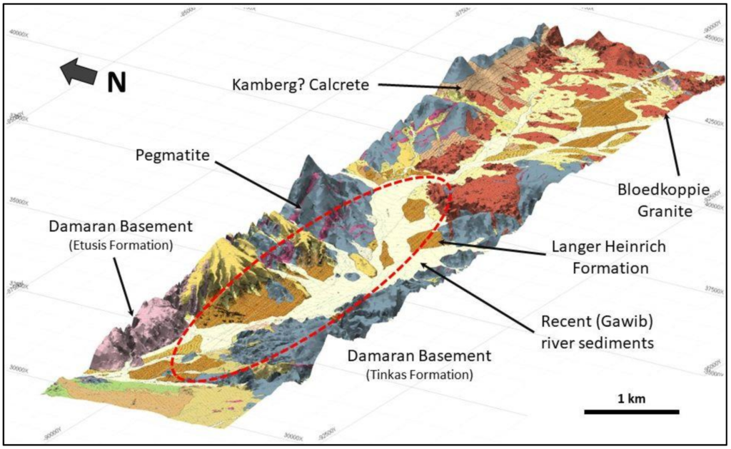
On EPL 8208, historical radiometric surveys reportedly identified unusual radioactive responses over potential paleochannels. These historical reports also describe carnotite in fractures and uranium values of up to 260 grams per tonne, equivalent to 260 parts per million. Drilling in the ancient valleys of the Gawib River reportedly found isolated mineralised zones below 100 parts per million U3O8.
Taken together, these historical results indicate both the presence of uranium mineralization at specific locations and indications of ancient drainages that may have influenced where uranium accumulated. A stronger-than-usual radiometric response can point towards primary uranium mineralisation, but it can also be caused by transported radioactive material in the underlying rock.
Now, I want to be careful here. Those results are historical. They are not a current mineral resource, they have not yet been verified through our own work with modern technology, and they do not establish continuity between the reported occurrences.
But, as I wrote in an earlier blog post What historical data tells us, and what it does not, historical results are useful because they help us ask better questions and more effectively direct exploration expenditures.
Our job now is to determine whether these separate clues begin to line up: whether the anomalies follow an ancient river channel, whether uranium continues below the surface and whether mapping, sampling and drilling all point towards the same target.
Two complementary opportunities
We previously explained how Skeleton Coast’s five-EPL position creates a portfolio of targets rather than a single geological bet. EPL 9727 and EPL 8208 show that logic at a more detailed scale.
This is why we see the two licences as complementary.
And, while being near the Husab, Rössing or Langer Heinrich open pit uranium mines does not guarantee that the same mineralisation continues onto our licences, nearby mines give us context and useful geological frameworks.
Now, we need to test those ideas on the ground.
What happens next
Our stated 2026-2027 work program includes reviewing and integrating historical records and government airborne data, followed by field mapping, sampling, geochemical or radon surveys, higher-resolution radiometrics and geophysics on selected targets, and first-pass drilling where the evidence supports it.
Neither model has yet been proven on Skeleton Coast Uranium’s ground, but that is our technically grounded reason opportunity — and what our exploration program is designed to find out.
The historical resource estimates provided here are based on data obtained and prepared by previous operators and have not been verified by either the Company or a qualified person as defined by NI 43-101 and the rules promulgated thereunder regarding the reporting of historical resource estimates. These estimates are considered historical and do not conform to current NI 43-101 standards.